

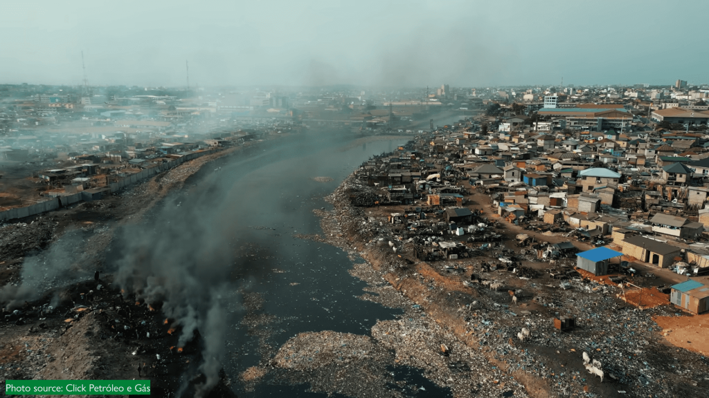
In the heart of Accra, where markets bustle and informal recyclers work tirelessly, waste burning remains one of the city’s most persistent threats to clean air.
Between August 2025 and January 2026, we conducted a study through the Zero Waste Accra Project on geo-spatial mapping sources of open burning and open dumping sites supported by the Clean Air Fund and Global Methane Hub. This study identifies where open burning and illegal dumping most threaten Accra’s air quality and urban resilience. The hotspot analysis focuses on a 5-district project area within the Greater Accra Metropolitan Area (GAMA) – Ablekuma West Municipal, Accra Metropolitan, Korle Klottey Municipal, La Dade Kotopon Municipal, and Ledzokuku Municipal, and does not extend to the entirety of GAMA. The work target’s locations where illegal dumping and open waste burning are most concentrated.
Using remote sensing, GIS-based point-density analysis, kernel clustering, and field surveys, the study aimed to quantify the spatial distribution and clustering of dumping and burn sites, visualize hotspots by activity intensity and frequency, and generate actionable insights to support targeted interventions, policy planning, and environmental enforcement.
Key Findings
High-Intensity Zones Identified
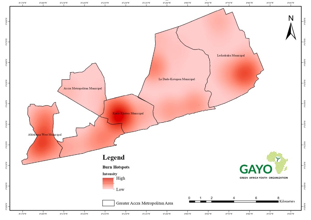
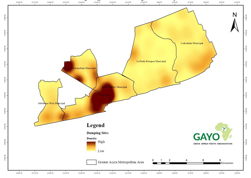
Jamestown/Usshertown, Chorkor, Korle Gonno, Korle Bu, Mamprobi, Makola Market, Agbogbloshie, Katamanto, Osu (Ringway/Kuku Hill), Adabraka, Asylum Down, Tudu & North/East Ridge emerged as the most environmentally burdened suburbs, with a very high density of both burn and dump sites. Ablekuma West recorded the highest number of burn sites, concentrated in Dansoman, Glefe, Gbegbeyise, Shiabu, Mpoase, and Old Dansoman. Accra Metropolitan recorded the highest number of dump sites, notably around Jamestown/Usshertown, Chorkor, Mamprobi, Korle Gonno, Korle Bu, Accra Central, Makola, the Neoplan area (VIP & STC stretch), Kaneshie Market, Agbogbloshie, and Kantamanto.
Spatial Hotspot Patterns
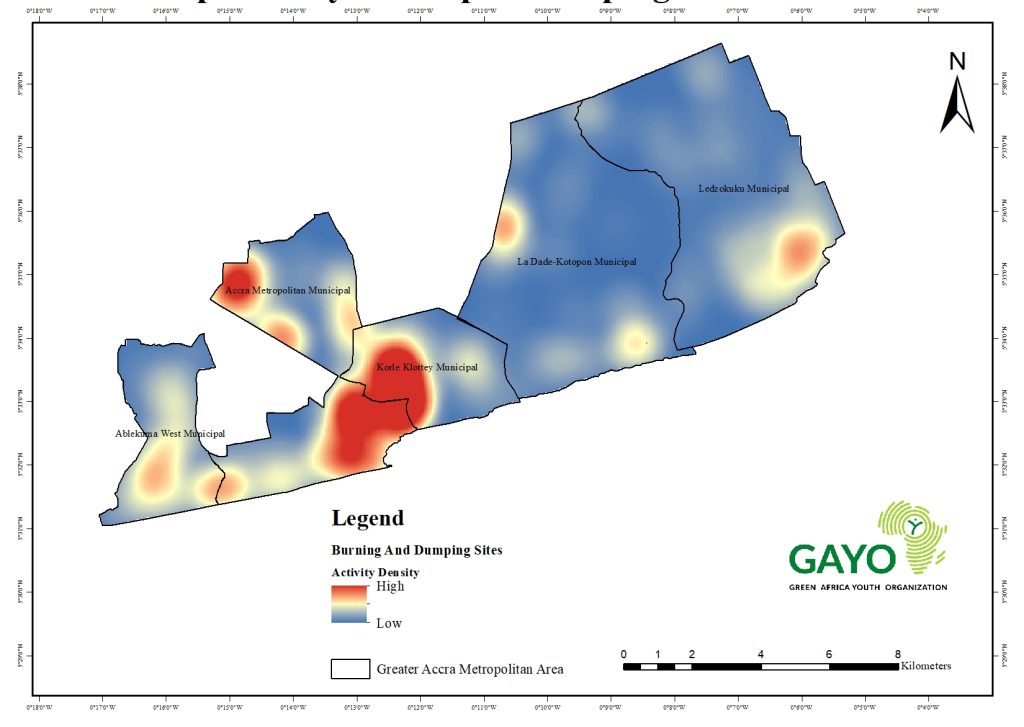
Burning hotspots were most intense in Dansoman; Glefe; Gbegbeyise, Shiabu, Mpoase, Old Dansoman/Manponse,Osu (Ringway/Kuku Hill), Adabraka, Asylum Down, Tudu, North/East Ridge, while dumping hotspots were highly concentrated in Jamestown/Usshertown; Chorkor; Mamprobi, Korle Gonno,Korle Bu, Osu (Ringway/Kuku Hill); Adabraka; Tudu; Asylum Down; North/East Ridge,Teshie (Tsuibleoo axis), Okpoi Gonno, Sutsurunor, Agblezaa, Aborle‑Bu; Akromadeokpo. Areas exhibiting both open burning and illegal dumping as confirmed by GPS-referenced field mapping and remote-sensing overlays—include Osu (Ringway/Kuku Hill), Adabraka, Asylum Down, Tudu, North/East Ridge, Jamestown/Usshertown, Chorkor, Korle Gonno, Korle Bu, and Mamprobi, marking zones of acute environmental stress and heightened public-health risk.
Municipal Disparities
Municipal Disparities
Municipalities exhibit distinct dominant issues—burning in Ablekuma West, dumping in Accra Metro and Ledzokuku, and combined threats in Korle Klottey & Accra Metro. La Dade-Kotopon shows a more balanced but emerging concern.
Environmental and Health Risks
Open burning contributes to severe air pollution and respiratory issues, while open dumping exacerbates urban flooding, water contamination, and the spread of diseases. Overlapping hotspots, confirmed through comparative GPS mapping, further amplify these interconnected risks across the five municipalities.
Major Hotspots Identified
Osu (Ringway/Kuku Hill), Adabraka, Asylum Down, Tudu, North/East Ridge,Jamestown/Usshertown, Chorkor, Korle Gonno, Korle Bu, Mamprobi,Accra Central Market,Agbogbloshie – The highest intensity zones. Likely linked to residual waste activity in and around central Accra, including areas historically associated with e-waste handling and urban dumping.
Dansoman; Glefe; Gbegbeyise; Shiabu; Mpoase; Old Dansoman– A southwestern hotspot where rapid urbanization may be driving localized open burning due to poor access to formal waste collection services.
Teshie (Tsuibleoo N/C/S), Okpoi Gonno, Sutsurunor, Agblezaa, Aborle‑Bu, Akromadeokpo, Teshie‑Nungua Estates,Okpoi Gono– A notable eastern cluster, potentially driven by informal settlement dynamics and edge-of-city dumping behavior.
The following results present key findings derived from the spatial hotspot maps of burn sites, dumping sites, and a combined burn‑and‑dump activity density surface, supported by temporal context drawn from published literature (2020–2024).
Open Dumping & Burn Sites
Burn Sites (counts)
Open Dumping Sites (counts)
Ablekuma West: burn-heavy, dump-light. Coastal communities (Dansoman axis) rely more on in-situ burning than hauling waste to informal dumps. Narrow lanes and high lot coverage reduce truck access; beach/lagoon buffers also limit spaces for persistent dumps. Focus interventions on household-level burning alternatives (door-to-door collection, communal bins, evening pickups) and by-law enforcement.
Accra Metro: dump hotspots concentrated around high-throughout markets & transport nodes. The very high dump count reflects the CBD’s daily inflow of traders/visitors and transient waste (markets, lorry parks). Priorities: market waste transfer points, timed collection around trading peaks, and targeted anti-litter enforcement.
Korle Klottey & Ledzokuku: mid-range on both metrics. Expect clusters near main corridors and mixed-use strips (Osu High Street / Ringway; Teshie High Road / Tsuibleoo). Pair corridor sweeping with micro-transfer sites and night pickups.
La Dade-Kotopon: lowest burn count. Large institutional land (Burma Camp), higher formal service coverage (Cantonments/Labone), and stricter estate by-laws suppress open burning, though pockets persist in Tse-Addo / Kaajaanor where infill growth is rapid.

Spatial Distribution of Hotspots
Burn Sites Hotspot Intensity – Five-District Project Area (GAMA)
Dumping Sites Hotspot Intensity – Five-District Project Area (GAMA)
Burning & Dumping Hotspots – AWMA, AMA, KoKMA, LaDMA & LeKMA
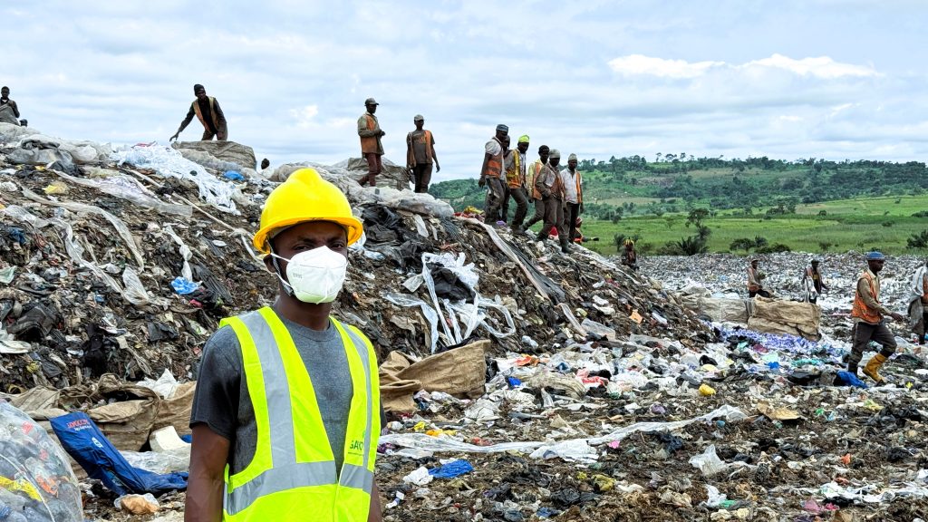
The spatial-temporal analysis of illegal dumping and burning in the Greater Accra Metropolitan Area (GAMA) reveals a complex interplay between infrastructure deficits, policy failures, market pressures, and informal systems. Hotspots are not static anomalies but dynamic indicators of systemic breakdowns particularly in municipalities where regulatory voids, weak enforcement, and rapid urbanization converge. The waste management challenges observed across the five focal districts within the Greater Accra Metropolitan Area highlight the urgent need for coordinated and data-driven interventions. Findings from the hotspot analysis show that addressing illegal dumping and open burning requires not only the enforcement of existing municipal bye-laws but also inclusive strategies that recognize and integrate informal waste actors. Expanding collection coverage, improving waste infrastructure, and linking waste management with flood control and public health measures will be key to building more resilient urban systems.
The waste hotspot crisis in GAMA remains addressable, but it cannot be resolved within the constraints of existing institutional frameworks. What is required is not incremental reform, but a systemic reorientation of urban waste governance, regulation, and strategic planning.
Recommendations
The spatial-temporal analysis of illegal dumping and burning in the Greater Accra Metropolitan Area (GAMA) reveals a complex interplay between infrastructure deficits, policy failures, market pressures, and informal systems. Hotspots are not static anomalies but dynamic indicators of systemic breakdowns particularly in municipalities where regulatory voids, weak enforcement, and rapid urbanization converge. The waste management challenges observed across the five focal districts within the Greater Accra Metropolitan Area highlight the urgent need for coordinated and data-driven interventions. Findings from the hotspot analysis show that addressing illegal dumping and open burning requires not only the enforcement of existing municipal bye-laws but also inclusive strategies that recognize and integrate informal waste actors. Expanding collection coverage, improving waste infrastructure, and linking waste management with flood control and public health measures will be key to building more resilient urban systems.
The waste hotspot crisis in GAMA remains addressable, but it cannot be resolved within the constraints of existing institutional frameworks. What is required is not incremental reform, but a systemic reorientation of urban waste governance, regulation, and strategic planning.